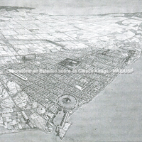
Reconstruction of Roman Carthage. Obviously, this reconstruction telescopes several phases of the history of a great city and may be misleading; nevertheless it gives an overall view of the city and its territory and a general idea of this ancient metropolis. The reconstruction shows the territory comprising the peninsula overlooking the Gulf, with Cape Sidi Bou Saïd to the north-east and the Salammbô harbour area to the south-east, and the spit leading to La Goulette can be seen. To the west, bounded by the Sebkha of Ariana and the Bahira, rises the isthmus linking the peninsula to the mainland. Across the whole peninsula two Roman cadastral surveys can be distinguished: the centuriation of the rural territory, cut into lots of 700 square metres; and, for the occupation of the coast, the cadastre of the urban area, laid out from the Byrsa hill, where the Decumanus Maximus was traced on the east–west axis and the Cardo Maximus on the north–south axis, defining orthogonal divisions. Within this rigorous grid, materialised on the ground by avenues and streets, are blocks where public and private monuments were built. Among the most important monuments we can distinguish those on the summit, the forum of Byrsa; to the west the amphitheatre and the circus; the harbour basins to the south-east; to the east the Antonine Baths and the Temple of Borj Jédid; to the north the theatre, the Rotunda, the Odeon and the aristocratic villae. On the plain to the west runs the route of the Zaghouan aqueduct, which ends at the great cisterns of La Malga.
Full-size image restricted
Nausitoo images are intended exclusively for academic research and teaching. To view them at full size, register and accept the Terms of Use, or sign in.