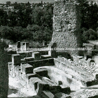
The site of the Byrsa hill at Carthage. The photograph shows, in the background, the coastal plain with the gulf dominated by Mount Boukornine; in the foreground we see a slope of the Byrsa hill with prominent Punic remains. The huge pier in the centre belonged to the foundations of a ruined Roman monument. The removal of the surrounding fills revealed Punic remains that had until then been buried. This was a residential quarter that revealed part of Carthaginian planning, made up of housing blocks built following a regular plan, probably under Hannibal's government. In the 2nd century BC the quarter was destroyed, like the whole area, when the city was captured by Scipio in 146 BC.
Full-size image restricted
Nausitoo images are intended exclusively for academic research and teaching. To view them at full size, register and accept the Terms of Use, or sign in.