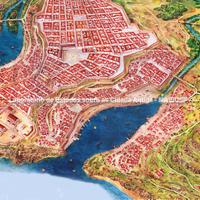
Reconstruction. Map. 5th century BC. Its name derives from wild celery (selinon in Greek), which used to grow there in abundance and became the emblem of the city, as can be seen on its coins. Selinous is still considered the closest to the ideal model of a city that ancient Greece has left us. Here we show a hypothetical reconstruction, since much of the city has not yet been excavated. Around 580 BC, the city was structured on a large urban plan based on the main North–South street (1) with regular side streets (100 Doric feet apart). The city was surrounded by a wall (2), of which few traces remain today. The concept of the Acropolis (3), as a fortified place on top of a hill, is not entirely accurate at Selinous, since it is used to indicate a large place of worship (4) and the residential areas located on the rocky spur facing the sea. The temples on the Acropolis are named with letters of the alphabet because it is not known to which deities they were dedicated. We indicate T.C (5), T.D (6), T.A and O (7), with their respective altars (8). The space in front of the temples was enlarged in the 6th century BC with an artificial terrace supported by a stepped wall (9), still clearly visible today, where a great colonnade (10) called a stoa stood. On either side of the city the rivers Modione (11) and Cottone (12) flow into the sea, and their mouths were used as harbours (13). There were two other sacred zones: to the west the sanctuary of Malophoros (14) and to the east, on the eastern hill, temples E, F and G (15). The walls still visible today were built after 409 BC, following the terrible destruction by the Carthaginians. These later fortifications (16) have been attributed to the tyrant Agathocles, who came from Syracuse around the end of the 4th century BC. In the vast area still to be explored towards the north, the agora (17) should be located. For more information, see the book "Selinus-Castelvetrano", La Medusa Editrice. Gates and walls project. Houses project.
Full-size image restricted
Nausitoo images are intended exclusively for academic research and teaching. To view them at full size, register and accept the Terms of Use, or sign in.