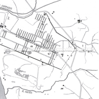
Plan of Kamarina in the time of Timoleon. Capital letters indicate the plateiai; numbers indicate the blocks. a. Dock area; b. Tower; c. Gela Gate; d. Sewer; e. Kilns; f. House of the altar; g. East Quarter; h. Temple of Athena; i. Tower; j. Quadrivium; k. Hyblaean Gate; l. Archaic necropolis of Rifriscolaro; m. Hill of Heracles; n. 6th-century BC street; o. Area of the sanctuary of Demeter; p. House of the inscription; q. House of the merchant; r. Undefined course of the city walls; s. City walls; t. Gate; u. Tower; v. Kilns; w. Classical necropolis of Passo Marinaro; z. Defensive wall of the 4th century BC. (D. Mertens and M. Schützenberger).
Full-size image restricted
Nausitoo images are intended exclusively for academic research and teaching. To view them at full size, register and accept the Terms of Use, or sign in.