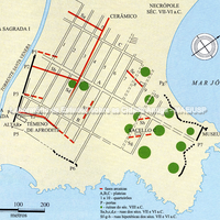
Urban plan of the 5th century BC with the Archaic phases shown in red. A, B, C: plateiai; 1 to 10: blocks; P 1-2: Gates. In green, ruins of the 8th century BC. Sa-b-c-d-e: streets of the 7th and 6th centuries. Sf-g-h: hypothetical streets of the same period. The continuous line represents the short course of the walls and the dotted line the hypothetical course. D. Mertens and M. Schützenberger.
Full-size image restricted
Nausitoo images are intended exclusively for academic research and teaching. To view them at full size, register and accept the Terms of Use, or sign in.