Herakleia

Italy (South) (Lucania)

Herakleia is a sub-apoikia of Taras and Thurii, founded in 433 BC with the intention of keeping control over the area called the Siritis (from the ancient colony of Siris, which had fallen under the domination of Croton at some date at the end of the 6th century BC or the beginning of the 5th century BC). It lived most of its active life under the influence of Taras, hosted the Italiote League and, like the other Greek colonies of Magna Graecia, fell under Roman rule from 272 BC.

Borders

Natural features: rivers, topography, sea

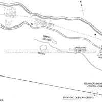
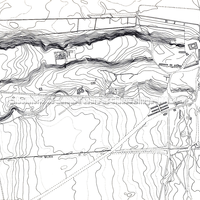
The urban core of Herakleia was laid out on a low, elongated plateau oriented east–west (north of modern Policoro) between the estuaries of the rivers Akiris and Sinni, in an area under the influence of the Greek apoikia of Siris, founded in the 8th century. Besides this plateau, the city occupied another, lower one on the south side, separated from the upper city by a depression that was also occupied. According to the most recent excavation data, it is possible to speak of occupation of the upper part, the lower part and the intermediate depression from the time of the foundation, over an area which, considering the limits set by the course of the walls, reached 140 hectares (Florenzano, 2006: 20).
Bibliography (2)
  • Florenzano, M. B. B.; A contribuição das colônias ocidentais na construção da identidade poliade: subsídios do uso e da organização do espaço.
  • Greco, E.; Magna Grecia: Guide archeologique Laterza

Relationship between ásty and khóra

Structures between ásty and khóra: walls, necropoleis, sanctuaries.

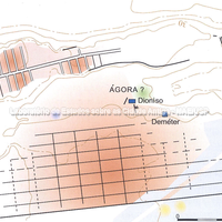
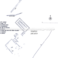
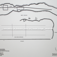
The whole urban grid was laid out in the second quarter of the 4th century, that is, about 50 years after the apoikia was founded (Cerchiai et al., 2004:126). In the upper part, excavations revealed a large plateia 10 m wide, oriented east–west along the whole plateau. This street was crossed at right angles by several stenopoi varying in width between 4.5 m and 8 m. Note that to build the plateia a cut was made across the whole plateau, so that this street lay lower than the houses and the stenopoi ran from a higher part down to the plateia, helping water to drain into this street, which carried it to its west side. Nor did the stenopoi cross the plateia; they were staggered on either side, facilitating the drainage of surface water. The central part, which was excavated, revealed pottery workshops together with houses, all occupied from the 4th century BC to the 3rd century AD. The east side of this upper part was slightly higher and had been occupied in the Archaic Siris phase by a sanctuary sector. In the lower part, excavations and aerial photographs revealed a set of eight plateiai, also running east–west, and another six streets oriented north–south. This grid has roughly the same orientation as the upper part of the city but is not articulated with it; it relates more to the direction of the city walls that ran through here. The depression between the upper and lower parts of Herakleia was occupied by several public areas, which in some way linked the two sectors: sanctuaries and the agora. This area lay outside the urban grid, and it is important to note that the sanctuaries were already in use in the Archaic period and were remodelled in the 5th century when Herakleia was founded (both that of Demeter and the so-called 'Archaic temple'). These may therefore have been extra-urban sanctuaries of Siris that were incorporated into the urban core when Herakleia was founded (?). The cemeteries lay on the east, south and west sides of the city, outside the 4th-century walls that ran there. The territory of Herakleia extended northwards, where the extra-urban sanctuary of Athena Polias and Dionysus was located (the find-spot of the famous Herakleia tablets), at the confluence of the rivers Cavone and Salandrella. On the south side farmsteads have also been found, some even with silos, such as that at Masseria Del Concio, 3 km from the city. The harbour installations were located at the mouth of the river Sinni (Florenzano, 2006: 20-21).

Bibliography (5)
  • Florenzano, M. B. B.; A contribuição das colônias ocidentais na construção da identidade poliade: subsídios do uso e da organização do espaço.
  • Mertens, D.; Città e monumenti dei Greci d’Occidente.
  • Labeca,; Foto Acervo Labeca
  • Juliis, E. M. D.; Magna Grecia: L’Italia meridionale dalle origini leggendarie alla conquista romana.
  • Longo, F.; Jannelli, L.; Cerchiai, L.; The Greek Cities of Magna Graecia and Sicily.

Forms of occupation of the ásty

Urban grid: acropolis, block, agora, plateiai, stenopoi, orientation

The organisation of the depression between the upper and lower parts of the city also seems to date from the second quarter of the 4th century, although individual buildings had layers earlier than this date. This area was divided into two large terraces, the larger occupied by a great temple oriented east–west, of which only the foundations remain today. The second terrace, immediately to the south and slightly higher, was surrounded by a wall probably lined with porticoes, marking the temenos of a sanctuary dedicated to Dionysus. Inside this temenos a building that seems to have been a hestiatorion (a place for ritual meals) was also found. Also in this central depression the sanctuary of Demeter was found, south-east of the sanctuary of Dionysus. More recently it has been proposed to locate the agora of Herakleia somewhere in the area free of buildings near this sacred area. This hypothesis, which unfortunately is not yet supported by archaeological finds, is based on examples of other agoras found in the Greek West that were centrally placed and served in some way as a point of contact and articulation between the various parts of the urban core (Pianu, 2001:89-92) (Florenzano, 2006: 21-22).

Bibliography (3)
  • Florenzano, M. B. B.; A contribuição das colônias ocidentais na construção da identidade poliade: subsídios do uso e da organização do espaço.
  • Mertens, D.; Città e monumenti dei Greci d’Occidente.
  • Greco, E.; Magna Grecia: Guide archeologique Laterza
Forms of occupation of the ásty

Walls and position of the gates

The upper part of the city was surrounded by a wall, dated to the 5th century, on the north, east and west sides. On the south side, the defences were incorporated into the terraces of the intermediate depression (Cerchiai et al., 2004:126). The lower part of Herakleia was walled at the beginning of the 4th century: stretches of wall of this period have been found that extended until they joined the walls of the upper part of the city, incorporating the depression between the two parts. On this south side of the walls, circular towers have been identified (Cerchiai et al., 2004:129) (Florenzano, 2006: 21).