Thasos

Greece (Aegean - North)

Thasos is one of the islands of the northern Aegean, near Macedonia and Thrace. The polis was founded by the inhabitants of Paros – an island in the Cyclades archipelago – around 680 BC, attracted by the gold, silver and marble deposits on the island. A few years later a second wave of colonists, also from Paros, took over some points on the coast of Thrace. Taking part in this second expedition were the lyric poet Archilochus (fr. 7 and 97 Belles Lettres) and Glaukos, to whom a monument was dedicated in the agora of Thasos (BCH 79, p. 76).
The commercial vocation of Thasos can be seen in the very position of the city, in the north-east of the island, facing the sea, acting as a bridge between the khóra that extended south of the urban core and its possessions on the mainland. Control of the surrounding maritime territory gave it access to an important trade route linking Athens to the Black Sea. And its foundations on the coast of Thrace, already in the Archaic period, acted as gateways to inland overland trade routes, spaces of passage and contact with the Greek and non-Greek world.
Herodotus (IV, 46-47) and Thucydides (I, 100, 2-3) state that the prosperity and power enjoyed by Thasos were due to the exploitation of the gold and silver mines on the island and the mainland, as well as its marble quarries. The accounts of Aristophanes (Pl. 1021) and Xenophon (Symp. 41), among other authors, recall the quality of the renowned wine produced in its island territory, and its export throughout the Mediterranean is further attested by finds of Thasian amphorae in many places up to the Roman period.
Because of its prosperity it was the target of various external interventions: first it had to submit to the Persian King Darius in 492 BC (Hdt. VI, 44), and in 477 it joined the Delian League, remaining for half a century under the "protection" of the Athenian empire (Thuc. I, 101, 3).

Reconstructions

Reconstructions

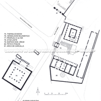
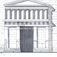
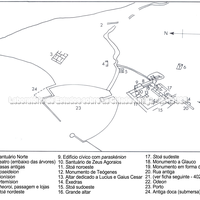
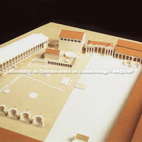
On the north-east side of the agora, as can be seen in this model, a Π-shaped portico was built in the second half of the 4th century BC which, from its architectural features and the presence of lists of magistrates and texts of laws, seems to have had a judicial function. North-west of this portico there was a bouleuterion able to hold about 300 councillors. On the opposite side, the Oblique Portico consisted of three banqueting rooms. In the Hellenistic period a series of shops and craft workshops was built on the south-east side. Two porticoes bordered the square, to the south-west and north-west.
Bibliography (1)
  • AA.VV.,; L`espace grec. 150 ans de fouilles de l’École française d`Athènes.
Research methodology

Archaeology of space

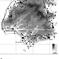
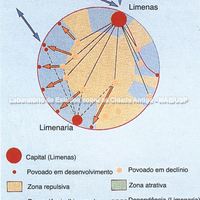
The location of the ásty in the north-east of the island and the various roads linking the urban centre with the khóra gave Thasos a very well-organised flow of goods and people between the ásty with its harbour and the komai scattered across the rural territory. This flow diagram also shows that occupation favoured the lower and flatter areas of the territory, spread around the island near its coast. Besides the roads crossing the khóra, coastal shipping also allowed goods to be carried more directly from their area of production or extraction to the harbour of the ásty, especially heavier goods such as marble and metals.

Bibliography (1)
  • AA.VV.,; L`espace grec. 150 ans de fouilles de l’École française d`Athènes.
Museum

Archaeological object

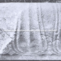
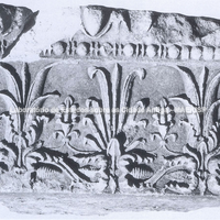
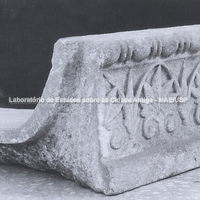
Example of a decorative moulding on display in the Thasos museum.

Bibliography (1)
  • Hellmann, M.; L’ Architecture Grecque. 1. Les principes de la construction.

Building techniques

Architectural details

Various architectural details with a decorative function, and details of wall-building technique.

Bibliography (1)
  • Hellmann, M.; L’ Architecture Grecque. 1. Les principes de la construction.

Forms of occupation of the ásty

Sacred areas: deposits, temples, shrines, sanctuaries, altars

Presentation and structural details of sanctuaries near the agora of Thasos, and their relationship with the urban grid of the centre.

Bibliography (1)
  • Hellmann, M.; L’ Architecture Grecque. 2. Architecture religieuse et funéraire.

Forms of occupation of the ásty

Walls and position of the gates

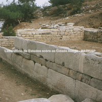
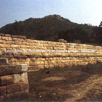
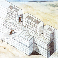
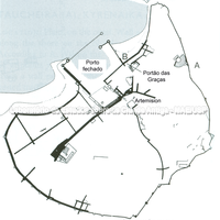
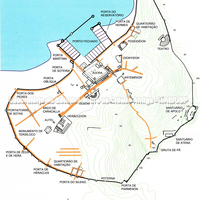
At the beginning of the 5th century BC construction began on the wall of Thasos, which finally marked the limits of the ancient city. The wall extended for a little over 4 km and enclosed an area much larger than that occupied by buildings. It started from the top of the acropolis, descended to the Evraiokastro promontory to the north, continued across the coastal plain to the west and reached the coast at the Closed Harbour, which was protected by its own circuit. It was this wall circuit that was partly destroyed on the orders of Darius in 491 BC. It was then restored and destroyed again, this time on the orders of the Athenians, in 463 BC, and was restored once more. The wall circuit visible today therefore dates from the end of the 5th century BC.
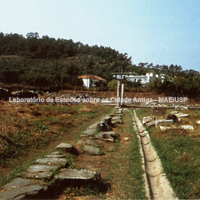
Several gates were opened along the circuit and named after deities whose apotropaic power was invoked in the defence of the territory. These gates connected the main spaces of the ásty and linked them to the roads leading to the harbour and the khóra. Around some gates, in the flatter zone, houses and commercial establishments developed, such as between the Gate of Silenus and the Gate of Heracles as far as the Gate of Zeus, south and south-west of the ásty, and at the Gate of Hermes, to the north-east.
The closed harbour, for military use, had its own circuit, which was nevertheless connected to the landward wall circuit; access from it to the city was through the Sea Gate.

Bibliography (3)
  • Frederiksen, R.; Greek City Walls of the Archaic Period, 900-480 BC (Oxford Monographs on Classical Archaeology)
  • Hellmann, M.; L’ Architecture Grecque. 1. Les principes de la construction.
  • AA.VV.,; L`espace grec. 150 ans de fouilles de l’École française d`Athènes.
Forms of occupation of the khóra

Sacred areas: deposits, temples, shrines, sanctuaries, altars

Aliki was a koma of Thasos, in the south-east of the island, on a near-island connected to the main island by an isthmus flanked by two small bays, to the south-east and south-west. An important marble quarry was located there, producing a quality used mainly in architecture.
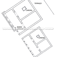
A sanctuary, probably dedicated to Apollo, was established near the eastern bay in the mid-7th century BC, shortly after the arrival of the colonists from Paros on the island. Although it is not known in its entirety, two buildings with identical plans, separated by an east–west street, have been excavated. The presence of an eschara in both buildings shows that they were not temples, but buildings for receiving worshippers and holding banquets and sacrifices. The sanctuary, which remained active until the Late Roman period, kept its maritime vocation, as shown by the names of passing sailors inscribed as graffiti on the façade of the north building, and the wishes for good sailing (εὔπλοια) to the ships that came to collect cargoes of marble, carved on sculpture bases. Indeed, an epigraphic document dated to the 2nd–3rd century AD refers to a traditional ritual of the magistrates of Thasos to Apollo Komaios: they sailed round the island, stopped at Aliki for an official visit, to offer sacrifices to the gods and to give thanks for good sailing (Salviat; Bernard 1967: 585-7, n. 32)

Bibliography (1)
  • Hellmann, M.; L’ Architecture Grecque. 2. Architecture religieuse et funéraire.

Forms of occupation of the ásty

Residential areas

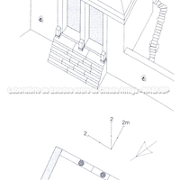
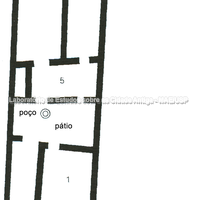
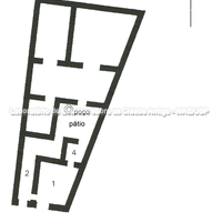
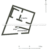
Some diagrams of residential buildings at Thasos, especially in the quarter near the Gate of Silenus, south of the city wall.
The first trace of occupation in the residential zone of the Gate of Silenus dates from the second half of the 6th century BC. This first structure housed a bronze-refining workshop producing objects in this alloy, as well as a goldsmith's workshop.
In the 5th century BC other dwellings were built on either side of a street that ran obliquely to the wall and determined the opening of the Gate of Silenus at this point in the walls. On the east side of this Street of the Gate of Silenus there were commercial establishments consisting of a single room; on the west side three dwellings were built, two of which opened onto the Wall Street and consisted of one or two rooms. The one opening onto the Street of the Gate of Silenus was larger and had two small rooms and a courtyard opening onto a large hall. Around 420 BC blocks I and II were extended northwards, and two streets running on the same axis as the Wall Street came to separate the new blocks III and IV.
The street running along the wall separated it from the houses, and north of this axis two other streets separated its blocks.

Bibliography (2)
  • Nevett, L. C.; House and society in the ancient Greek world.
  • AA.VV.,; L`espace grec. 150 ans de fouilles de l’École française d`Athènes.

Forms of occupation of the ásty

Urban grid: acropolis, block, agora, plateiai, stenopoi, orientation

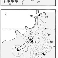
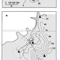
Characterised by the contrast between a mountainous centre and its peripheral coastal plains, the siting of the urban centre in the north of the island, facing the mainland, reflects a conscious choice by the colonists regarding the distribution of their various spaces. The connection between the various parts of the island, with roads linking these spaces by sea or by land, along the coast and through the interior, is part of an ordering of space resulting from the agricultural and mercantile vocation of Thasos, which allowed the flow of its production towards the city and its harbour. As this map shows, the ásty, in the north-east of the island, was connected by roads to the komai distributed around the island, which ensured the flow of production and access between the city and the sanctuaries of the khóra. Rural properties were spread across the lower parts of the island, and near them were the pottery workshops where the amphorae in which Thasian wine was traded were produced. On the coast several lighthouses were built to guide the coastal shipping practised around the island, as well as forts that gave the territory greater protection.
The Aliki Stele, an epigraphic inscription dated to the mid-5th century BC and published in 1964 by the French scholars Fr. Salviat and J. Servais, indicates the three extreme points of the island and the distances between them: the distance between the urban centre and Aliki, passing through Ainyra (where there is an important marble quarry); from Aliki to the Diaison, referring to the Sanctuary of Zeus (Diaison) at Demetrion; and finally from the Diaison to the city, along the coast. Besides the connection and circulation between the extreme points of the island, by means of this circular road covering the whole territory, the inscription underlines the importance of the rural, extra-urban sanctuaries at the southern end of the island as points unifying the territory and integrating the population living in the khóra and the island's eschatia.

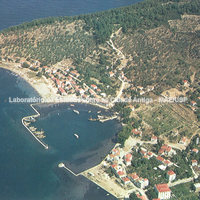
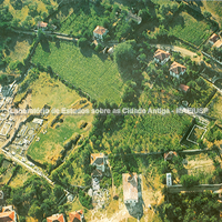
The Greek city had two harbours: the open harbour, for trade, and the closed harbour, for military use. We have no reliable information on the settlement and way of life of the first colonists. In any case, it can be seen that the space where the city's main sanctuaries would be located was defined very early: the Pythion and the Athenaion on the acropolis, and on the lower slopes of the acropolis the Artemision and the Herakleion. From the outset these points served as references in organising the space of the ásty, and the first residential zones developed near them: in the north-east sector, near the Artemision, and in the south-west sector, near the Herakleion, linked by a great arterial road.
At the end of the 6th century BC, to the north, on the Evraiokastro cape, what can be identified as the Sanctuary of Demeter and Kore was built – in an area that a few years later would be left outside the city walls – whose temple was reused as an Early Christian church in the 5th or 6th century AD.
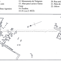
The agora is not known archaeologically in the early years of the colony. However, from the Harbour Stele, an epigraphic document published in 470–60 BC, we know that by that date there already existed a prytaneion, a banqueting hall and a money-exchange (άργυραμοιβήϊον) – the first reference in Greek epigraphy to a word designating a building of this kind. In this Stele the streets bordering the agora and shaping the Classical square are already present: the street of the Sanctuary of the Charites, linking the Herakleion to the Artemision and bordering the agora to the south-east; the street passing the prytaneion, whose position is still debated but which certainly connects with that of the Sanctuary of the Charites; and finally the street running from the Herakleion to the sea, which, even though not yet identified, certainly led to the Fish Gate.
In the 4th century BC a political, religious and economic reorganisation of the city resulted in an urban restructuring, with public and private works, many of them paid for by rich Thasian and foreign benefactors, as the inscriptions attest. It was then that the form of the agora became fixed, following an orientation already defined in the 6th century BC. The Sanctuary of Zeus Agoraios, the Building with Paraskenia, the North-east Building, the North-west Portico and the Tufa Building were built in the public square, and on the south-east side, along the great artery, a portico bringing together shops, workshops and probably residential units.

Bibliography (3)
  • Schoder, R. V.; Ancient Greece from the Air.
  • AA.VV.,; L`espace grec. 150 ans de fouilles de l’École française d`Athènes.
  • Cunliffe, B. (ed.); Osborne, R. (ed.); Mediterranean Urbanization 800-600 B.C.