Phaistos

Greece (Crete)

Phaistos lies on three hills near the Mesara plain and the river Geropotamos, from where one can see Psiloritis (Mount Ida), the sacred cave of Kamares and the Asterousia mountains to the south. The earliest evidence of occupation at Phaistos goes back to the end of the Neolithic period (end of the 4th and beginning of the 3rd millennium BC). At the beginning of the Bronze Age, Phaistos was the ancient capital of the southern and central region of Crete during the Old Palace period and housed the best-known palace on the island at that time (La Rosa, 1992: 232). Studies of the pottery in the deposits of the settlement have shown continuity in the occupation of Phaistos from the end of Late Minoan III to the Iron Age (La Rosa, 1992: 235). For the Archaic period, pottery remains of the Orientalising period, and of the Archaic period in general, are rare. A law inscription found in the bed of an irrigation channel near Chalara dates from the end of the 6th century BC. This inscription, older than the Gortyn Code, mentions property of a mother and an agora. It was probably displayed in a public building and is an important source of information on the topography of Archaic Phaistos (La Rosa, 1992: 235). Finds of the Classical period are few: vases, terracottas and coins. The Hellenistic settlement underwent a remarkable expansion, becoming as large as the Minoan city. The palace area was entirely covered with houses, there was a precinct or a temple of Apollo or Asclepius, and the Hellenistic city was surrounded by a defensive wall (La Rosa, 1992: 238).
Phaistos was dominated in the second half of the 3rd century BC by Gortyn, a city with which it shared its border. That polis destroyed Phaistos in the 2nd century BC and the city was never rebuilt. In the Roman period Phaistos was no more than an isolated khóra with only a few farmsteads (La Rosa, 1992: 238).

Forms of occupation of the ásty

Residential areas

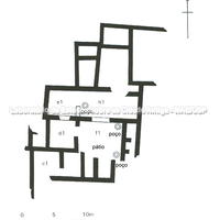
On the south-eastern slope of the hill, in the Chalara quarter, excavations carried out between 1960 and 1964 revealed numerous residences on terraces, belonging to the last phase of life of Phaistos, between the 3rd and 2nd centuries BC, which preceded the destruction of the area by Gortyn (Torelli; Mavrojannis, 2002: 426).
Bibliography (3)
  • Torelli, M.; Mavrojannis, T.; Guide Archeologiche Grecia
  • Nevett, L. C.; House and society in the ancient Greek world.
  • Myers, E.; Cadogan, G.; Myers, J.; The Aerial Atlas of Ancient Crete
Forms of occupation of the ásty

Urban grid: acropolis, block, agora, plateiai, stenopoi, orientation

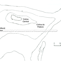
During the 8th and 7th centuries BC the settlement occupied the three hills (from west to east: Christos Efendis, the Central Hill and the Palace Hill), where the Minoan city and palace had stood. At the beginning of the 6th century BC the settlement came down from the hills and was established on the plain. Very probably the Central Hill, the highest of the three (110 m) and the only one fortified during the Subminoan/Protogeometric and Geometric periods, served as the city's acropolis (Hansen; Nielsen, 2004: 1180).

Bibliography (4)
  • Hansen, M. H. (ed.); Nielsen, T. H. (ed.); An Inventory of Archaic and Classical Poleis.
  • Frederiksen, R.; Greek City Walls of the Archaic Period, 900-480 BC (Oxford Monographs on Classical Archaeology)
  • Myers, E.; Cadogan, G.; Myers, J.; Rosa, V. L.; "Phaistos"
  • Myers, E.; Cadogan, G.; Myers, J.; The Aerial Atlas of Ancient Crete