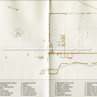
Plan of the city of Dion.
Dion lies at the eastern foot of Mount Olympus, at the end of the plain of Pieria. The ancient city was built in a commanding position on the road from Thessaly to Macedonia. In antiquity the polis was only 1.5 km from the coast of the Thermaic Gulf, which could be reached by the river Vaphyras – the link with the sea – east of the city. The territory of the Classical polis was bounded by Leibethra to the south, Pydna to the north-east and possibly Phylakai to the north-west (Hatzopoulos, 2004: 800; Mackay, 1976: 276; Touratsoglou, 2004: 251). The name of the city derives from the genitive Διός and expresses the connection of the place with the cult of Zeus, probably because of an ancient festival called Dia, whose name in turn derives from the Macedonian month Δῖος (Kremydi, 2004: 19; Voutiras, 2006: 335).
The site of Dion comprises the area of the sanctuaries, on the open plain to the south, and the walled part to the north, covering a total of c. 43 hectares. The orthogonal street grid, which left an open space for the agora, is contemporary with the construction of the walls dated to the end of the 4th century BC. Probably built by Cassander after 305 BC, in the pre-Roman period, the walls had a regular rectangular perimeter of c. 2,625 metres, about sixteen towers and a total of six or seven gates (Hatzopoulos, 2004: 801). The sacred area of the city is entirely extra-urban, and its extent confirms the character of Dion as a "holy city", suggesting the hypothesis of a development independent of the complex inside the walls (Mari, 2002: 54, note 2).
The ancient cult of Olympian Zeus, at the foot of Mount Olympus, acquired a reputation far beyond the local level, became the national cult of the Macedonians and was used as an instrument of political propaganda by the kings (Voutiras, 2006: 337 and 338).
Relationship between ásty and khóra