Reconstructions
Bibliography (1)
- Juliis, E. M. D.; Magna Grecia: L’Italia meridionale dalle origini leggendarie alla conquista romana.
Italy (South) (Campania)
Cumae was the first Greek apoikia in the West (Strabo 5.4.4). The archaeological evidence points to Greek colonists at Cumae from 750–725, the same date as the earliest Greek evidence at Pithekoussai, suggesting a first phase of settlement contemporary with that of the neighbouring site. The city was founded by Chalcis in Euboea, or by Chalcis together with Eretria. According to Strabo (5.4.4), there were two groups of colonists: one led by Hippokles of Kyme in Euboea, and the other led by Megasthenes of Chalcis.
The hinterland of Cumae was fertile, but the city stood out as a maritime settlement. There is a tradition of landing places in the territory of Cumae, such as the site of Dikaiarcheia, very early in the history of the city.
Mineral extraction also seems to have played an important role at Cumae. Neapolis was probably founded in the 5th century BC as an apoikia of this polis.
The territory of Cumae extended north to the river Klanios, the boundary between the areas of Greek and Etruscan influence. The territory covered about 280 km². There is little evidence of sanctuaries in the territory of Cumae; however, the sanctuary of Demeter on the plain north-west of Neapolis dates to a period before the foundation of the city and can be taken as evidence of a rural sanctuary in the territory of Cumae. Traditions about the travels of Heracles also point to the existence of rural sanctuaries dedicated to this hero. The influence of Greek Cumae in the Italic region should not be underestimated: an important point is that the Etruscan alphabet has a Euboean-Cumaean origin. (Hansen, 2004:270-1)
Reconstructions
Reconstructions
Borders
The position of Cumae, in an area of direct contact with the Etruscans, explains part of the city's life. The city lay at the northern edge of the Phlegraean Fields, on the coastline. It was protected by the islands of Ischia and Procida and to the south by Cape Misenum. In the area, before the arrival of the Greeks, there was an indigenous settlement (9th–8th centuries BC) on the rocky outcrop called Monte di Cuma.
 Map of Campania with the location of Cumae, Neapolis and Pithekoussai (after Cerchiai…
 Map of the territory of Cumae (after Frederiksen 1984, map II).
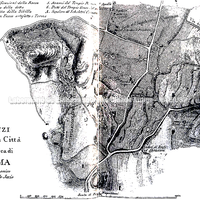 Old map of the location of the polis of Cumae
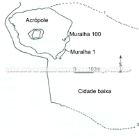 Cumae. General plan of the site and of the Archaic fortifications. Archaic walls (1, 100…
General views of the settlement highlighting the relief and the position of the acropolis
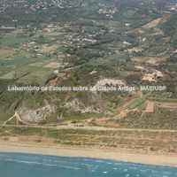 Aerial view of the rocky spur extending to the north and east, on which the colony stood…
 View of the acropolis of Cumae, the first Greek colony in the West.
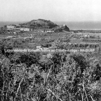 General view of the Acropolis.
Forms of occupation of the ásty
Sacred areas.
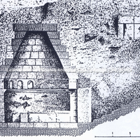
In the second half of the 6th century BC, Monte di Cuma was levelled and received the huge temple of Apollo. Although there is some controversy, the temple of Apollo would have been related to structures perhaps built by the tyrant Aristodemus at the beginning of the 5th century BC, associated with a monumental fountain and cisterns.
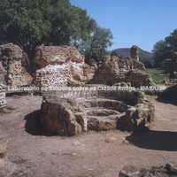 Ruins of the "Temple of Jupiter" (Zeus) on the acropolis of Cumae. In the foreground, the…
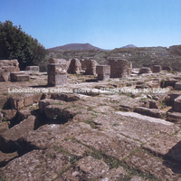 Ruins of the Temple of Apollo on the acropolis.
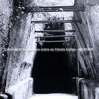
The cave of the Sibyl became very famous in the Roman period: there the Sibyl delivered oracles of all kinds and was much consulted. However, the cave in which she received those who consulted her was probably built at the end of the Archaic period; it was spatially related to the acropolis, and inscriptions indicating the presence of the cult of Hera were found there.
Museum
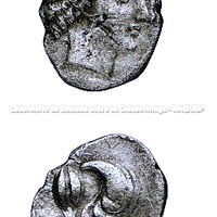
Cumae struck coins from about 500 BC. It is interesting to note in the coin types of this city the persistent depiction of the shell, a distinctive mark of its access to the riches of the sea.
Forms of occupation of the ásty
Cumae had walls as early as the Archaic period (6th century BC). These walls enclosed an area of 110 ha.
Old map of the location of the polis of CumaeCumae. General plan of the site and of the Archaic fortifications. Archaic walls (1, 100…Relationship between ásty and khóra
Plans of the city showing the organisation of space in the Greek and Roman periods. Campania was the first region occupied by Greeks to be incorporated by Rome (323 BC). The Campanian cities thus underwent a great deal of Roman building intervention from that time on.
Monte di Cuma, the site of the earlier indigenous settlement, became the acropolis of the new polis with the arrival of the Greeks. The inhabited area of the city lay between the acropolis and Monte Grillo to the east (Cerchiai, 2002, 44-45). The city covered an area of 6 km² – not very large. It had two harbours, one of them in the Licola lagoon, which had access to the sea.
The Greek necropoleis lay north of the settlement, along the 3 km route skirting Lake Licola (Cerchiai, 2004, 45)
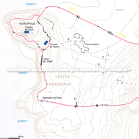 Campania was the first region occupied by Greeks to be incorporated by Rome (323 BC). The…
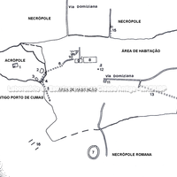 Plan of the city
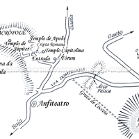 Plan of Cumae and its surroundings.Old map of the location of the polis of Cumae